Page 1 of 1 pages
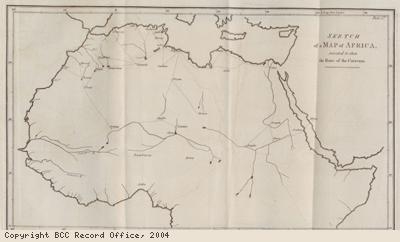
Report: map of routes of Arab traders
Description:
Lords Committee of Council reports, 1789.
The Lords Committee of Council was a Parliamentary Committee.
The title of the reports reads: Report of the Lords Committee of Council appointed for the consideration of all matters concerning the present state of the Trade to Africa and particularly the Trade in Slaves …
Map of Africa showing routes of caravans of Arab traders.
Small numbers of enslaved Africans were sold from the east coast of Africa to other areas, including the Persian Gulf and India for hundreds of years. (The Persian Gulf is today the area including Iran, Iraq, Saudi Arabia, Oman and the United Arab Emirates).
The numbers of enslaved Africans sold to these areas increased in the late 18th century. This was because French merchants bought slaves from East Africa for the growing sugar plantations on the French owned islands in the Indian Ocean. Brazilian merchants also began buying slaves from the same area for the sugar plantations in Brazil, after 1800.
Then, trade to the Persian Gulf and India increased rapidly. By the early 19th century about 30,000 people were being sold into slavery from this eastern area of Africa. They were being bought and sold through the main centre of the trade on the island of Zanzibar (off the east coast of Africa, of what is now the country of Tanzania)
Date: 1789
Copyright: Copyright BCC Record Office
Page 1 of 1 pages